Investigations in summer 2014

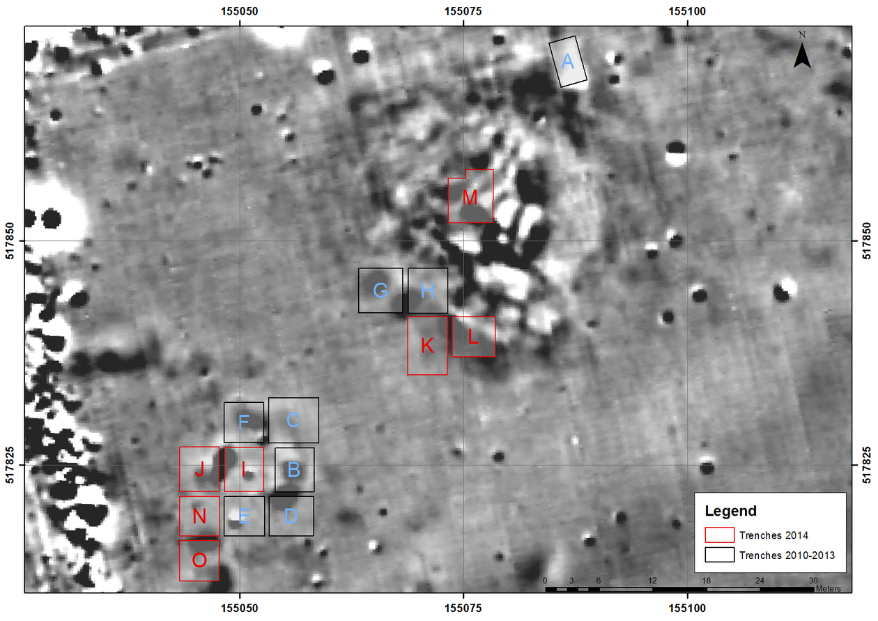
Due to the results from the years 2012 and 2013, the settlement areas at the tumulus as well as the area southwest to it were expanded. The main focus of this research was on the one hand, to answer the question about Early Neolithic structure, and on the other hand, to create a time frame of the post Neolithic settlement patterns in this area. Therefore, the southwest area was expanded by the trenches I, J (each trench: 4,5x5 m), and by N and O (each trench 4,5x4,5m). The trenches K and L (each 4,5x4,5 m with an expansion of trench K to the south by 2x4,5 m) were structured southeast to trench H (from the previous year excavation) in the north-eastern settlement area. For further clarification of the technical methods used in the first excavations by Kisléghi Nagy Gyula (Gall/Ciobotaru/Tănase 2010), and to possible narrow down the time-frame of the tumulus, a further trench, trench M (5x5m), was opened approximately in the centre of the hill, which later on was expanded 2x3 m to the north.
Accompanying geomorphologic investigations by Bastiaan Notebaert (see report attached) revealed, that the, on the geomagnetic mapping, apparent finding free stripe between the settlement areas, is a landscape depression, on which ground deposits from a Neolithic settlement can be expected. In contrast to the north and south courses of branches from dried out rivers in relation to the habituated area, this depression is not the result of a branch from a river, since no associated sediments were found in the borehole detections. Under the instruction of Elena Marinova, areas within the old river branches, with the potential preservation of organic material, were probed for palynological studies. The zoological material from the previous year excavations were defined by Béatrice de Cupere. Further studies on a selection of fish bones and mollusc shells are planned at the Natural History Museum in Brussels.
In addition to the studies of previous years, the process and methodology from the excavation in 1904 by Kisléghi Nagy Gyula were reconstructed in detail. It was possible to follow the south-western edge of his excavation with trench L. The southern profile of trench M in particular shows the sondages created by Kisléghi. Along with the already mentioned traces of the old excavation, visible in the geomagnetic mapping, it is now possible to reconstruct the excavation activities from 110 years ago in detail. The Kisléghi trenches are relatively irregular stripes with a tub-like cross section extending in a north-eastern direction. The gained sediment from one trench was poured into the last exposed trench. Evidently not all finds were recovered from the surface, as a large find accumulation was piled up against the border of the old cut edge.
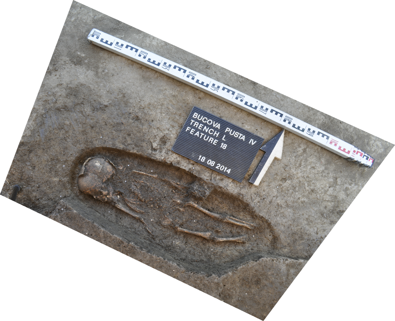
Within the range of the tumulus three entire burials, in the trenches K, L and M, from the early Middle Ages were recovered. Like in the previous year, more human skeletal remains were found in the old Kisléghi trenches, which apparently come from graves that have been uncovered at that time. The discovery of two glass beads in the grave of an infant as well as a bronze bead in the grave of an adult male, give for the first time a clear indication for the dating of these graves. Due to similar finds from Hungarian cemeteries, the burials can be dated to the late 8th and the early 9th century AD. Based on the fragility of the infant’s grave, it was recovered en bloc and was further exposed under laboratory conditions at the Museum of the Banat Bulgarians in Dudeştii Vechi. Because of its high value, it is now displayed in a glass cabinet as part of the exhibition.
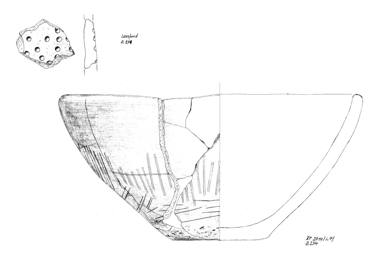
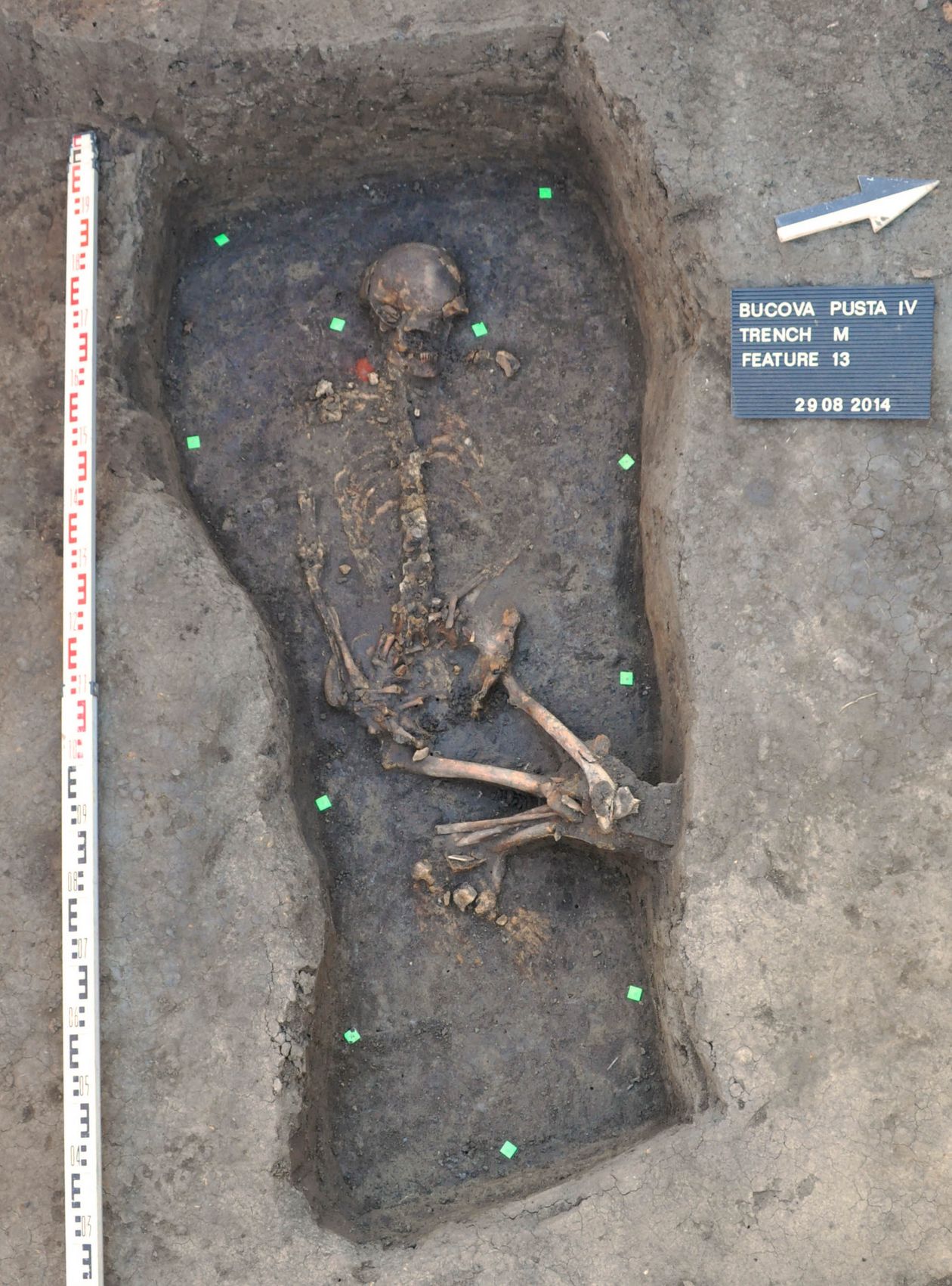
One of the main results of the excavation campaign of 2014, are the indications for the dating of the tumulus. In the northern half of trench L a cremation burial of an infant covered with an urn was salvaged. The vessel is a bowl with a slightly inwards curved edge, which, based on the characteristic incised decoration at the outside, can be assigned to the Baden-Cotofeni group in the Banat. On the northern border of trench M a grave with an inhumation appeared, for which recovery an extension to the north was necessary. The burial was only grazed by an overlying section of the old excavation from Kisléghi and otherwise untouched. The grave pit was slightly trapezoidal in shape with, towards the feet, slimming contours. The bottom of the pit was completely covered by a dark matter, which could be the result from a past organic material, possibly a mat. In the underlying sediment, in the area of the ankles and the head, are traces of three small post tracks, which indicate a grave installation. The grave contained a provisionally determined elderly woman lying on her back with slightly to the left offset bent knees, due to earth pressure. In the chest area were numerous shells of snails, which, according to the zoologist, could not be explained by taphonomy. They are therefore seen as grave goods. In addition to the shells a shaped piece of red ochre on the right of the woman’s head was found. The type of this burial and the piece of red ochre suggest that we are dealing with a classic ochre grave dating from around 3000 BC, the late Copper Age. This grave could possibly be the central burial of the tumulus, and the cremation burial of the child can be regarded as a secondary burial from the same time period. The cultural and historical significance of the ochre tomb lies in its geographical position, since it is one of the westernmost burials of a funeral custom that comes from the Northpontic area (see Ecsedy 1979, Fig . 3).
Early Neolithic Settlement
In the south-western settlement area in the trenches I and J, another tall pit was documented (fig. 7). The structure of the feature is curved and shows no defined outline. Approximately in the centre of this pit is a smaller pit, like a well, in which a complete foot vessel was found. The finding has exclusively been filled with Early Neolithic artefacts. The backfilling reconstruction however is very complex and appears to have occurred in several episodes. Respectively an interpretation of this finding is difficult. Apparently, this area was first used for extraction of construction clay and was later used for water extraction. The shape of the pit is too irregular to be considered as a building feature. Nevertheless the feature is to be seen in the context of the Early Neolithic settlement activity on the Bucova Pusta.In the area south of the pit, the terrain descends into an old watercourse one, visible in the geomagnetic mapping. For clarification, two further trenches N and O were opened south to trench J (fig. 7). Especially in the south of trench O, the descent of the natural surface is clearly visible. Along the banks of the old river arm are still many Early Neolithic finds, including another completely to be reconstructed vessel. The find concentration in this area suggests that this old river branch existed contemporary with the Early Neolithic settlement. The geomorphological investigations this year however, could not be pursued to confirm this situation due to lack of time.
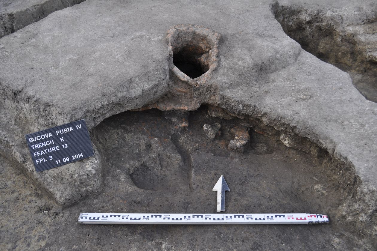
In the north-eastern settlement area a very complex setting in the trenches K and L could be documented. The Early Neolithic features are disturbed by later pitting and therefore at times still quite unclear. Clearly however is another Early Neolithic pit in the north between the trenches K and L, which has already been observed in the south section of trench H in the previous year. This pit has no regular shape as well and shows a complex filling chronic with Early Neolithic settlement material. One of the most important findings this year is another oven in the northern section of trench K (fig. 8). Similar to the oven from trench G, which was documented in the previous year , this is as well an out of the ground modelled freestanding oven. However in this case, it obtains a very elaborately designed dome, which leads into a cylindrical flue. The southern part of trench K shows other Early Neolithic pitting, which are all heavily cut by later disturbances. It is becoming apparent that the old terrain descends strongly in this area. Contrary to the original assumption, it seems, as mentioned earlier, in accordance with the geomorphologic investigations to be a terrain depression. This depression is filled with black sediment, which could be rearranged material form the eroded tumulus. A terminus ante quem for the filling of this valley offers another Early Medieval grave, which was embedded into this dark filling.
The opened excavation was documented photographically by the company “Andron Solutions” with a Quadrocopter form the air. These recordings can now be used to complete the already recorded station measurements of the terrain model.
All sediments samples of the Early Neolithic features, taken in the previous year, were flotated at the excavation camp at the Museum of the Banat Bulgarians in Dudeştii Vechi. An archive data system was set up for the finds, which allows investigations at any time by other scientific experts. The labelling was done entirely in English, in order to enable international work. The community Dudeştii Vechi, offered us the possibility to set up a new archaeological exhibition at the museum in the future, to display the most important results of our research.
Literature:
I. Ecsedy, The People of the Pit-Grave Kurgans in Eastern Hungary. Fontes Arch. Hung. (Budapest 1979).
E. Gáll/D. Ciobotaru/D. Tănase, Kisléghi Nagy Gyula – Archaeológiai Napló (Szeged/ Timişoara 2010).
R. Krauss
Translation by Franziska Mandt