Investigations in summer 2015
")
Excavations at the site of Bucova Pusta IV
In the time from the 3rd of August till the 30th of September 2015 we managed to open four sections with a total area of 120 m².
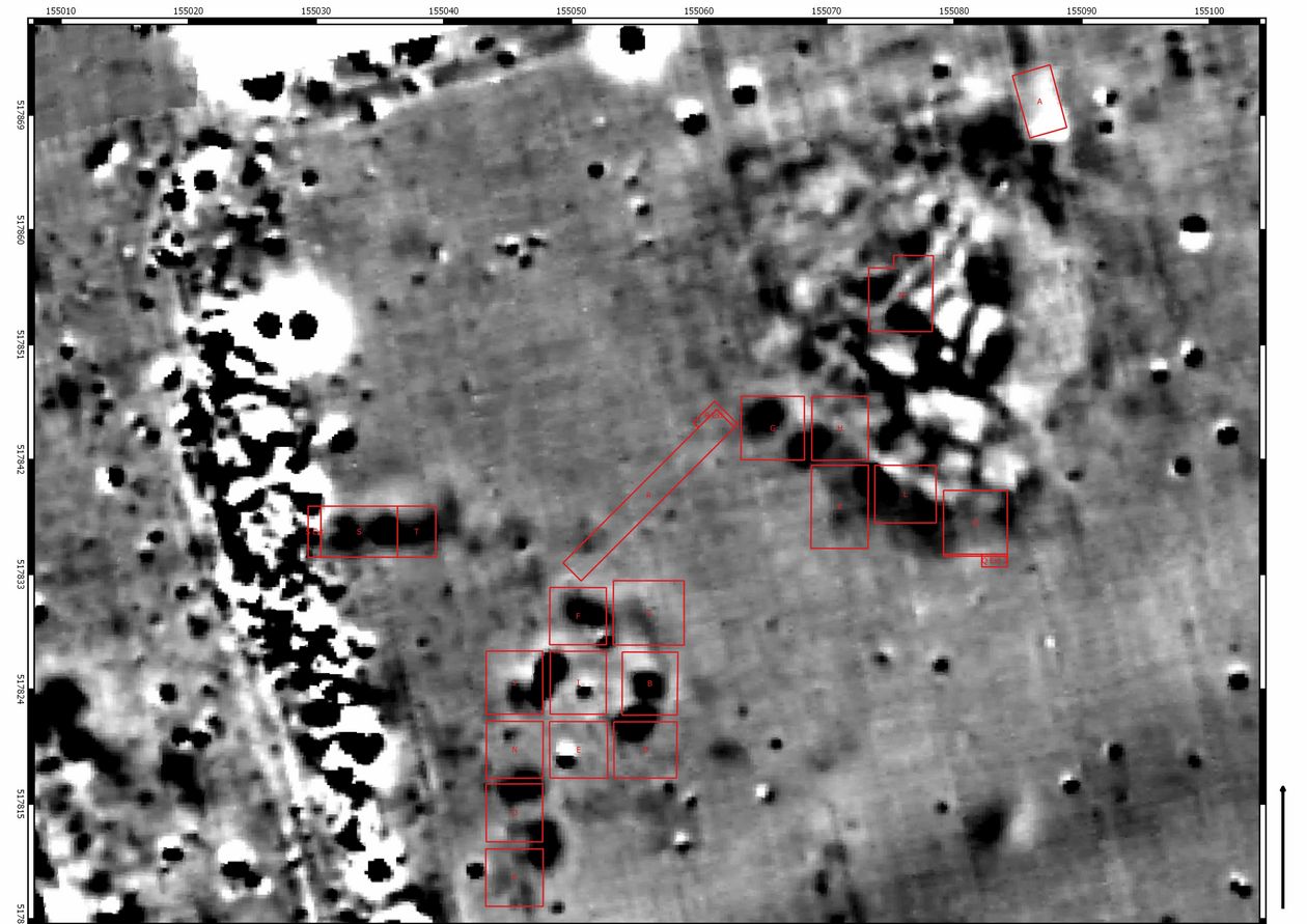
Trench P: This 4.5 x 4.5 m trench was dug out in the southern extension of last year’s trench O.
The purpose of this trench was the examination of the southern settlement-border. The geomagnetic map shows that the settlement is bordered by an old course of a river. In this area there were several Neolithic features, without clear contours, found in the slightly southwards-sloping natural soil. These features include a series of pits, which overlap each other to some extent. Noticeable is that a lot of flint artefacts were found, which make up more than 50 % of all found flint artefacts of Bucova Pusta IV. All of these artefacts are either complete or fragmented finished tools but there is no sign of flint artefact production in the site. This settlement area was supposedly primarily used for the extraction of clay and secondarily for garbage disposal. The large number of flint artefacts suggests that this area on the southern settlement border was used for crafting activities.
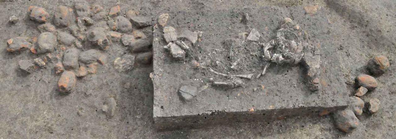
Trench Q: In line with the trenches K and L from the previous year, an additional trench with an area of 5 x 5 m was opened in the eastern part of the settlement. Because of the Copper Age tumulus excavated by Kisleghi Nagy Gyula in the last century, which can be clearly seen on the geomagnetic scan, this sondage was shifted 2.5 m to the south. In the northern part, the south-eastern border of the previous year’s trench is clearly visible. In the southern part, a long ditch could be documented over its whole extent. This ditch was already visible in previous year’s trench L. The filling’s finds date post-Neolithic, most probably early Iron Age. In the south-eastern corner, another medieval grave was found. The grave’s north-south orientation clearly differs from the other already excavated medieval graves. In order to fully excavate the grave, the trench was extended in this part one meter to the south. The skeleton was in good condition, with very few bones not in their anatomical order. In the chest and hip area, various iron and bronze artefacts could be documented, which can be interpreted as a belt’s metal fittings and buckle. They seem to belong to the late Avars. In all of trench Q, there were only relocated, Early-Neolithic artefacts found.
Trench R: This 17 x 2 m trench runs from the south-west to the north-east, diagonally between the previous year’s trenches C and K. This trench was created to examine a signal-poor, linear strip on the geomagnetic scan, which goes through the whole Early-Neolithic settlement. Last year’s geomorphological examination gave the first clues for cultural debris on the bottom of this oblong depression. Further examinations, undertaken by a geomorphological team from the University of Szeged led by György Sipos, could prove the existence of a former stream course, which was covered by a loess-like sediment during the last Ice Age. At the arrival of the early Neolithic settlers, the old stream course must have still been visible in the landscape. In the trench’s western part, an early Neolithic artefact was found at the bottom of the depression and above it another from the early Iron Age. Above this horizon, late Iron Age grey wheel-thrown pottery has been documented in the middle of the trench. In this trench there was an Early-Neolithic, an early Iron Age and a late Iron Age layer. It was after the late Iron Age, when this valley-like, linear structure completely filled up, to today’s surface. This last filling was apparently caused by one single natural occurrence, because the soil above the archaeological features is sterile, humic-dark and of a uniform consistency. In the north-eastern part of the trench another medieval child burial was found and so the trench had to be extended in this area for 40 cm to the north-east and for 60 cm to the north-west in order to block-lift it out.
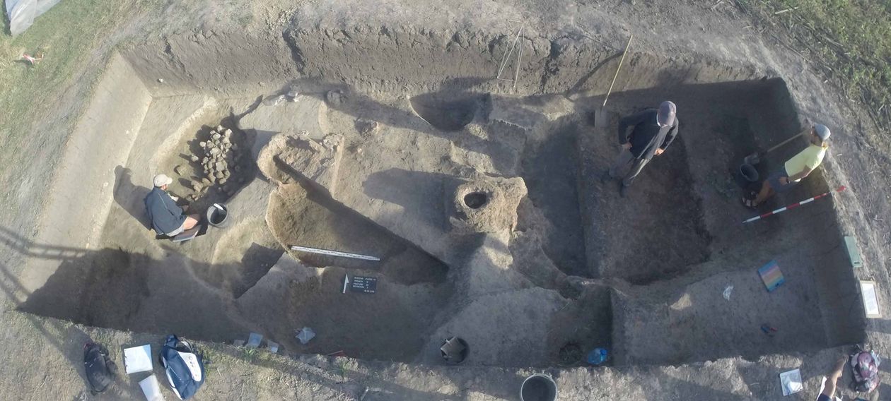
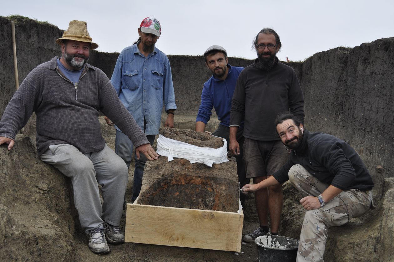
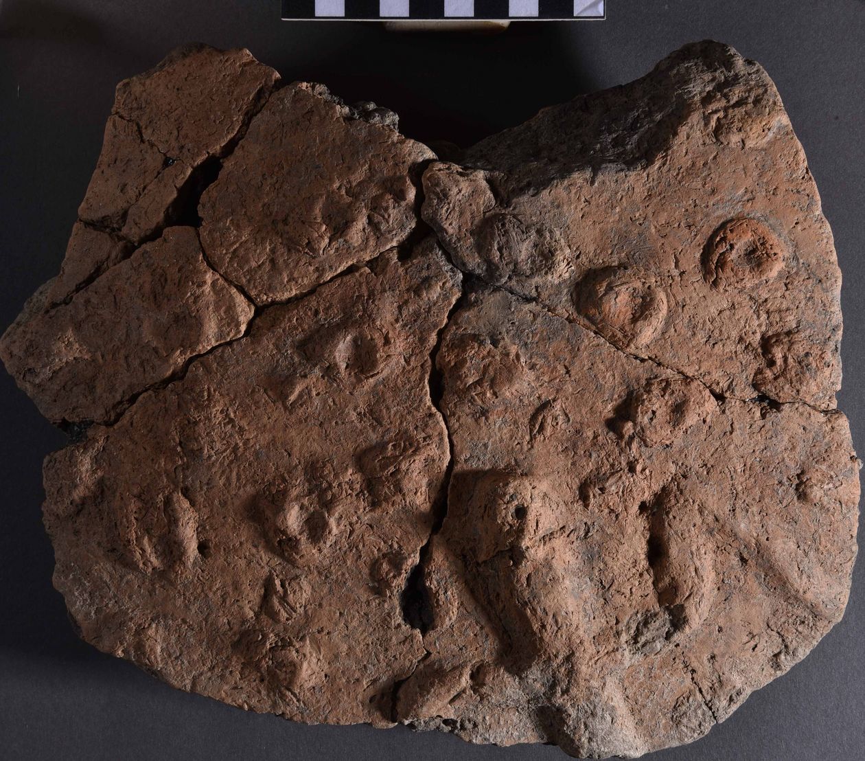
Trench S-T: At first a 6 x 4 m big trench was created in the north-west of the site. Its purpose was the examination of structures which appeared as large black shadows on the geomagnetic scan. At a depth of 60 cm, many early Neolithic structures already appeared and continued to the east. For this reason the decision was made to extend this trench with another 5 x 5 m trench to the east. This new trench was called Trench T. From 60 cm depth downwards, two larger settlement-structures, which were put into the sterile soil, were documented. The eastern one of them turned out to be a pit house with two ovens in it. Those ovens were from the western wall dug into the surrounding natural grown soil. The northern one (S7) had a collapsed dome and could only be documented in the field. The other one (S6) was in a very good condition and had a chimney in its dome-structure. This oven was block-lifted and is stored in Dudestii Vechi’s museum for further examinations under laboratory conditions. West of the first pit-house another one was found, which also had two ovens in its western part. In contrast to the others, they were not dug in the natural soil but were erected as a dome structure. In the trench’s far west (west of the second pit-house), a north-south orientated child-burial was excavated. It is a westward-facing crouched burial, which had been placed above a deposit of over 60 Early-Neolithic clay weights. The sediment filling of the grave also contained only Early-Neolithic finds. Two samples were taken in order to do a 14C-dating. One sample was taken from the child’s long bone and another one from an animal bone which was found in the burial’s sediment filling. After preliminary studies of the fieldwork, all of trench S-T’s features date to the early Neolithic.
Trench I-J: In the area of the one-time trench I-J, a small section with the dimensions of 2 x 2 m was re-opened to continue excavating an Early-Neolithic well-shaft. Because of last year’s high ground-water level the excavation had had to be canceled. The re-opened shaft was now fully excavated to its bottom at a depth of 2.24 m. In the shaft’s filling, additional large Early-Neolithic pottery sherds were found.
Excavations at the site of Kalcsov I
The site is located 1.4 km to the east of the village exit and approximately 33 m north of the road to Sânnicolau Mare. It was discovered by the former history teacher of Dudestii Vechi, Konstantin Kalcsov. The meadow doesn’t have its own name but lies immediately to the south of a distinctive burial-mound in the meadow “Na pesaka”, or “on the sand”. Surface finds imply a settlement of the developed Early-Neolithic. Only very few Early Iron Age materials were found. To clarify the stratigraphy, a first sondage-excavation was conducted from the 9th of August to the 2nd of September. Directly to the south of the path, a trench with the dimensions of 5 x 5 m was created, cutting the site in a west-eastern direction.
The first feature not affected by plowing appeared at a depth of 30-40 cm. It is an oblong pit-house, which was excavated in the trench’s north-western corner with a 2.5 x 1.7 m trench. The feature continues into the northern and western profile. In the eastern part of the house, an oven platform was excavated at a depth of 0.9 m. This platform gets cut by a deeper, pear-shaped pit at about 2.5 m below the surface and which goes as far down as today’s groundwater level. It could have been a storage pit or a well. The finds from the pit-house filling date to the Early Iron Age. In the center of the trench at a depth of 0.9 m, a small round pit was documented, in which a large Hallstatt-period pot, which can be completely reconstructed, was excavated.
Many Early-Neolithic pottery sherds (Starçevo-Criș) were found in secondary position. Neolithic finds were not discovered. The surface finds’ distribution implies that the Early-Neolithic settlement’s center will be located north of this year’s trench.
Translation David Matzig